Switch Theme:

Real world maps vs Fantasy Maps: Which makes sense?  [RSS] Share on facebook Share on Twitter Submit to Reddit
»
Author Message
Advert


Forum adverts like this one are shown to any user who is not logged in. Join us by filling out a tiny 3 field form and you will get your own, free, dakka user account which gives a good range of benefits to you:
  • No adverts like this in the forums anymore.
  • Times and dates in your local timezone.
  • Full tracking of what you have read so you can skip to your first unread post, easily see what has changed since you last logged in, and easily see what is new at a glance.
  • Email notifications for threads you want to watch closely.
  • Being a part of the oldest wargaming community on the net.
If you are already a member then feel free to login now.


Made in gb
[DCM]
Et In Arcadia Ego


Canterbury

http://worldbuildingschool.com/real-world-maps/


Real world maps vs Fantasy Maps: Which makes sense?
Over the past few years I’ve been introduced to a number of ways that gamers are using apps to turn real world maps into gaming platforms.

The first example I ever encountered was a game called “Ghost Escape”. Essentially the game took a smart phone’s GPS and implanted “ghost sightings” on it. Players would use the map to locate the ghosts, scoring points.

It was simple, straight forward, and turned the real world into a game board.

A recent venture into this would be kids game “Dragons Adventure”. This tablet game allows children on road trips to fly DreamWorks characters and dragons through the same terrain they are driving past, weather and all.

Of course, these interactions are all designed and built using the latest GIS technologies and GPS systems and modeling software and programmed by serious code monkeys. Fortunately, us old school gamers can utilize some of the same principles without having to be app designers equipped with phones that are smarter than we are or $500 software.

We just need to know what makes real world maps so fascinating people design games around them, then design our maps to capture the same things.

When you pull out a real world map there are certain things about it that just make sense. Let’s take a look at an example.

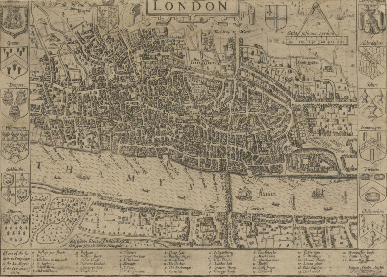
This is London in 1653.


As you look at it you discover that there are a lot of elements about the city that just plain make sense when you think about them.

First, there’s the distribution of the city in regards to the map. Notice that there is next to nothing of the city on the south bank.

At first that might seem odd, but think about it.

The Thames is a huge river, and London formed as a trade town specifically because it was a good location for ocean traffic to find a safe harbor. Bridging the Thames blocks off access to the river for ship traffic, so it is not something you would do unless overland traffic had become far more valuable.

Once trade was established on the North bank, anyone who tried to build on the South bank would be cut off from the actual trade center and all of its amenities by the river. So the city grew exclusively on the northern side. Only with the bridging of the river on a permanent basis would the south start seeing significant development.

This same logic explains the position of the castle on the map.

That’s the Tower of London. If you visited it today it’d be near the heart of the city. But on this early map, it’s very much on the edge of both the town and the river.

Again, taking in mind the purpose of London, it makes sense.

The same sea trade that made London the thriving trade hub it was also represented the biggest approach of attack on the city.

A raiding fleet could sale right up to the city armed to the scuppers with soldiers and siege weapons.

By putting the fortress right at the start of town and directly on the bank you have your strongest city defenses poised to destroy anything trying to get at the soft and flammable buildings upstream. The other defenses are scattered throughout the city, at times on an edge, and other times buried deep in the guts of the town. The city didn’t stop growing because someone built a wall. It kept expanding, spilling out over the walls and rendering them moot.

Then, finally, there’s the roads.

When you look at that map of London there’s not a straight road on there.

Again, though, this makes sense.

London was not some sort of planned city using protractors and rulers to lay it out. When people started settling there they built along the river and expanded outward by following cattle trails and goat paths. As the animals wandered from watering spots to grazing spots their trails twisted in and about the terrain. So, to, did the roads that people formed by using those trails, and so follows the paths of the buildings lining those roads.

It’s an organic structure, messy, convoluted, and very natural.

Now, to contrast that, let’s take a look at a map of one of the most famous fantasy settings out there.

This is a map of Tolkein’s Osgiliath (post-abandonment).

The one-time capital of Gondor in The Lord of the Rings.


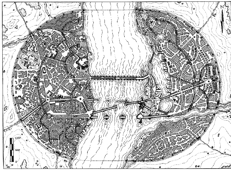
Like London it’s a city built on a major river and serves as a port for ships full of cargo.

But look at how everything is arranged.

I’m a major fan of Tolkien, but this city makes no sense when you start thinking of it practically. First, the city is almost evenly distributed across both banks of the river.

Think about that.

This river is nearly half a mile wide, but the population managed to nicely build their city evenly on both banks. The only way this would make sense would be if they bridged the river right off the bat. They would only do that if they felt the loss of all river traffic north of the bridge was worth it, and frankly, it wouldn’t be for a long time to come.

Worse, the Southeastern quarter is cut off from the Northeastern quarter by the tributary flowing from Minas Ithil. There’s no bridge, no way to get across it. And yet it is as heavily built up as the rest of the city.

As for the bridges…

Map of Osgiliath's HarbourThese two sides are joined by bridges that are even more nonsensical than the sides themselves. As you can see, near the shore of the East bank are a series of islands that form a natural port separated from the rest of the river. However, both ends of that port are blocked off by bridges. There are numerous docks and wharfs and no way to access them with vessels larger than overgrown canoes.

Then there are the defenses.

Osgiliath’s primary bastion may be on the banks of the river as well, but it’s also as close to the center of the city as you can get without actually getting in the water. That’s it edging slightly into the Northwest portion of the map.

There’s not a single portion of the city that it actually defends.

In fact, the bridges are protecting it from any water bound attacks coming from the sea. This makes no tactical sense.

Added to that, the outer walls don’t feels natural or real. Their perfectly circular arcs don’t conform to the landscape. Rather, they force the landscape to conform to them.

This is city planning at its most draconic, allowing no room for development.

When you look at the contour lines it is clear that the landscape has either been dug out and evened to fit the city, or that the landscape was unnatural indeed. Further, the city has been forced to conform to the walls. There is no waste space inside the walls, nor are there any structures outside.

Then there are the roads. While there are certainly roads which twist and turn like those of London, all of the major roads have been placed with a straight edge.

Unlike London, whose most important streets are the goat paths that were built along first, someone has bulldozed a straight path through whatever development had existed before to create order. As for those that do twist and wiggle many look less like they are wandering someplace and more like they are being impeded and blocked at every turn by the buildings.

Osgiliath, according to this map, just doesn’t feel natural.

It doesn’t look like something that was founded in a place that made sense and then grew from there, it feels like something that was created whole cloth in defiance of the very reason it was located where it is. It simply does not make sense.

So what’s the takeaway here?

The real world map of London makes a better fantasy setting than the fantasy map of Osgiliath.

Looking at a map of London you get this sense of a living, growing city that has a history and a reason to exist. It excites you about the possibilities of being someplace vibrant and a touch unruly.

By comparison Osgiliath feels sterile, like it always has been there and always will be, and never will it be touched by anything so puerile as history.

When you are working to create maps for your fantasy setting take lessons from real world geography.

Real World Maps Make Sense

Build your fantasy cities like the cities actually live. Found them in a location that makes sense, and then have the cities grow up over time around that city. Grab something like Campaign Cartographer, AutoREALM or a blank map; plug in a geography that makes sense for the campaign, and then grow the city over time.

I guarantee that building fantasy maps the way real world maps formed will result in a more natural and exciting setting.


Seems somewhat obvious once it's been pointed out but true nevertheless.

I must admit that too many of the maps I've done in the past have been guilty of over designing perhaps, and often one suspects too much symmetry as well.


The poor man really has a stake in the country. The rich man hasn't; he can go away to New Guinea in a yacht. The poor have sometimes objected to being governed badly; the rich have always objected to being governed at all
We love our superheroes because they refuse to give up on us. We can analyze them out of existence, kill them, ban them, mock them, and still they return, patiently reminding us of who we are and what we wish we could be.
"the play's the thing wherein I'll catch the conscience of the king,
 
   
Made in ie
Norn Queen


Dublin, Ireland

Fully agree Red. I struggle constantly even setting up gaming terrain on my boards. I have a very bad habit of everything being angular, symmetrical and somewhat unnatural even on boards that are supposed to be organic (feral worlds etc).
Theres something to be said for having a more random, organic approach which real life maps can provide. Nature is wonderfully random and organic after all.

Dman137 wrote:
goobs is all you guys will ever be

By 1-irt: Still as long as Hissy keeps showing up this is one of the most entertaining threads ever.

"Feelin' goods, good enough". 
   
Made in gb
Highlord with a Blackstone Fortress


Adrift within the vortex of my imagination.

I dont think that map is Tolkiens but a gaming companies idea of Tolkien's works.
Tolkien had fairly solid ideas about city architecture. Tolkien just upped the scale because cliff design is a staple of high fantasy and blamed the Numenoreans or Saurons magic..
Minas Tirith is a citadel, it was not intended for mass habitation but for defence.

n'oublie jamais - It appears I now have to highlight this again.

It is by tea alone I set my mind in motion. By the juice of the brew my thoughts aquire speed, my mind becomes strained, the strain becomes a warning. It is by tea alone I set my mind in motion. 
   
Made in gb
[DCM]
Et In Arcadia Ego


Canterbury

I think that the Osgiliath map is from one of the old/venerable ICE M.E.R.P. books/supplements ?

Certainly seems familiar anyway.

The poor man really has a stake in the country. The rich man hasn't; he can go away to New Guinea in a yacht. The poor have sometimes objected to being governed badly; the rich have always objected to being governed at all
We love our superheroes because they refuse to give up on us. We can analyze them out of existence, kill them, ban them, mock them, and still they return, patiently reminding us of who we are and what we wish we could be.
"the play's the thing wherein I'll catch the conscience of the king,
 
   
Made in us
Posts with Authority


Might be relevant - a lot of these guys are super serious about this stuff.

http://www.cartographersguild.com/content.php
   
Made in us
Longtime Dakkanaut


Well obviously real maps are going to be more realistic, they're real. I'm not sure that means realistic is universally better. Maybe you just want a map that's kind of loose that lets you fill in on the fly to adapt the game as players do things, maybe you want to build up an area that has some symbolic meaning, maybe you want something that's only built that way due to some special or magical property of the world, maybe you just want a map that's pretty to look at.

The idea that "More Realistic" or "More Practical and Natural" = "More Exciting" is just silly. Taste is a thing, and people's tastes vary. Like maybe it's really important to me and the feel of my setting that a city looks like big ol' dong. Maybe any concerns about how practical the layout is, or how it'd "Really" affect trade is less important than the small roads going out looking like pubes, and the major gate to the city being right at the tip.

This message was edited 1 time. Last update was at 2015/05/02 19:34:35


Made in de
Joined the Military for Authentic Experience


Nuremberg

I'd agree with what Chongara is saying. There's times when you want a "realistic" map, and then there's times when you're better off with something a bit less real.

Symmetry is easier to remember, and having your players be able to quickly internalise your fictional geography is pretty useful. Finding your way around London in the 1600s would have been a pretty difficult task, and players can quickly disengage if the level of complexity gets too high or hard to remember. That said, some nods to realism help ground the map and immerse the players, so I'm not saying realism is always bad, either.

But like, Sigil from Planescape for example is never going to abide by any conventional geography, arranged as it is on the inside of a floating ring on top of an infinitely tall spire, with gates to every place in the multiverse scattered throughout it's Wards. And that's fine

Still, interesting stuff and all views are useful when putting together your toolbox.

   
Made in us
Using Object Source Lighting


Portland

The big problem with the OP argument is that it assumes an organic evolution of a city. Particularly in Asia, even quite long ago, capitals/major cities were built withe a larger plan in mind from the beginning, where they didn't evolve organically: the given nobility or their staff or w/e picked a location and then there was a ton of building and up sprang a city, which eventually started to organically change, but started extremely structured.


My painted armies (40k, WM/H, Malifaux, Infinity...) 
   
Made in au
Unstoppable Bloodthirster of Khorne


Melbourne .au

Not really a problem, IMO. There's still the issues of working with/in/around the existing landscape and geography, which makes sense in terms of the city walls, growth on one side of a river vs the other and also harbours. I don't see that sort of thing as at odds with the Asian example.

This message was edited 1 time. Last update was at 2015/05/03 19:44:59


Made in us
Hauptmann


NJ

It doesn’t look like something that was founded in a place that made sense and then grew from there, it feels like something that was created whole cloth in defiance of the very reason it was located where it is. It simply does not make sense.


Spoiler:


(Spoilered because of size)

(Washington D.C. ; built on a swamp because the southern states couldn't bear the capital being in the north)

I think the author's point is valid in many cases, as I feel it is certainly common to tend towards order in world design, but I think it does not take into account all settings or cities, as a great many cities WERE centrally planned.

It has already been mentioned about the cases of centrally planned cities in Asia, but both the Romans and Greeks also tended to have a central plan to their cities, that often kept them (at least for a while) very geometric and orderly. The author does not take into account the power of large empires (for the Romans) or cultural/religious beliefs (for some Greek colonies) in shaping a city to form in a less than organic structure.

Though his points are worth noting many cases where a rigidity and order appears inadvertently, I think there are certainly times in a fantasy setting where a city that is unnaturally planned could be both fitting and interesting, such as showing a contrast between a strong and rigid empire, making the world bend to their will, and a separate city state that originated organically.

This message was edited 1 time. Last update was at 2015/05/04 23:31:37


Flames of War:
Italian Bersaglieri
German Heer Panzerkompanie


Made in gb
Fixture of Dakka


Washington, D.C. was planned and built during the industrial revolution, though - not during the ancient/medieval period which is the time most fantasy RPG settings tend to emulate.

Note that it's still on one side of the Potomac, in any case.

There's an interesting contrast if you look at Manhattan below the Brooklyn Bridge. Even there, it's been straightened out somewhat, but the original seventeenth century "organic" street layout contrasts nicely with the grid layout to the northwest. Or Paris, where the bits that Napoleon rebuilt run right over the old city. That, to me, is the sort of thing you'd see in your fantasy capital.

The other point, about the position of fortresses, walls, etc, still stand. It's particularly egregious in the case of Osgiliath since Gondor was still in a state of war against Mordor at the time; someone should have thought better about where that fort went. At the very least, I'd expect onion-like repeated rings of walls as the city grows, and multiple forts as the edge of the city moves downstream.

I've just gone and looked at a map of Ankh-Morpork, funnily enough, and it shows some of the same issues the author of that blog complains about. However, the differences are explained in a few ways.

Firstly, it originally formed as two separate cities on opposite banks, as is the case with Budapest in Hungary, London - that area on the south of the river in the map in the OP isn't London, it's the separate city of Southwark. Westminster is a third settlement a bit downriver - and the urban area of New York/Newark.

Secondly, there are explicitly areas of development outside the walls, but they're just left off to fit the main urban centre onto the poster. The novels imply that building outside the city walls was discouraged until recently, resulting in overcrowding and buildings being extended upwards and outwards over streets. The city is built as far upstream as oceangoing ships can navigate anyway, so bridges aren't a barrier to the exploitation of the river. They might have caused barriers to riverine traffic, but A-M is pretty close to the mouth of the river, so even that's not much of a problem.

As an aside, that's quite often why cities grew up where they did; either the furthest upriver that ships could reach, or the furthest downriver where it could be forded (as with the city of Glasgow). Things like that are also worth considering when siting your fantasy settlement, rather than just bunging one down in an otherwise empty area of the map.

Thirdly, there's the visual style of the map itself. That map of London has individual streets drawn, and lots of little houses and buildings, trees, ships on the river, and all sorts of frilly bits round the edge. The Osgiliath map, by contrast, looks too plain and "modern" (in an early 80s way).Presumably this is because the artists working for RPG have time constraints and aren't cartographers by trade.

Further down the blog, the author puts his money where his mouth is:

http://worldbuildingschool.com/how-to-design-a-town/

This message was edited 1 time. Last update was at 2015/05/26 09:33:09


Made in us
The Conquerer


Waiting for my shill money from Spiral Arm Studios

I think criticism of the Osgiliath map is a little unfair. The Numenorians obviously planned the city out. City planning is certainly not out of the question for the greatest civilization that ever existed in Middle Earth.

Also, as I recall the bridges over the Anduin were quite tall. Ships could easily pass under. Not that that was necessary, there weren't many major cities to trade with upstream. Certainly not that you would trade with using ocean going vessels. There also wasn't a particular side of the river that would be favored to settle on. Osgiliath was directly between Minas Arnor and Minas Ithil.

Also, there actually is a bridge between the southeastern section and the rest of the city. Its just been destroyed like most of the other bridges.

This message was edited 2 times. Last update was at 2015/05/26 15:54:37


Self-proclaimed evil Cat-person. Dues Ex Felines

Cato Sicarius, after force feeding Captain Ventris a copy of the Codex Astartes for having the audacity to play Deathwatch, chokes to death on his own D-baggery after finding Calgar assembling his new Eldar army.

MURICA!!! IN SPESS!!! 
   
 
Forum Index » Board Games, Roleplaying Games & Card Games
Go to: